
Topografische kaart Drexel Heights
Interactieve kaart
Klik op de kaart om de hoogte weer te geven.
Over deze kaart
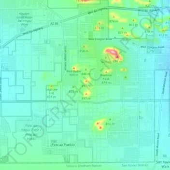
Naam: Topografische kaart Drexel Heights, hoogte, reliëf.
Gemiddelde hoogte: 786 m
Minimale hoogte: 747 m
Maximale hoogte: 984 m
The area has numerous Saguaro cacti, and is positioned only a couple of miles south of the Saguaro National Park. The northern boundary of Drexel Heights is the Tucson Mountain Park. It is cut off from the rest of Tucson due to the topography of the Tucson Mountains, which are only crossed via a small number of roads: Ajo Highway is the main crossing, with Gates Pass providing a more scenic route. Coyotes and Javalinas are commonly sighted in the area.
Andere topografische kaarten
Klik op een kaart om zijn topografie, zijn hoogte en zijn reliëf te bekijken.
Tucson
United States > Arizona > Pima County > Tucson
Tucson, Pima County, Arizona, 85701, United States
Gemiddelde hoogte: 836 m
Agua Caliente Wash
United States > Arizona > Pima County > Tucson
Agua Caliente Wash, Powder Horn Ranch, Tucson, Pima County, Arizona, United States
Gemiddelde hoogte: 791 m
Catalina Foothills
United States > Arizona > Pima County > Tucson
Catalina Foothills, Tucson, Pima County, Arizona, United States
Gemiddelde hoogte: 949 m
Mitchell Park
United States > Arizona > Pima County > Tucson
Mitchell Park, Mountain 1st Avenue, Tucson, Pima County, Arizona, United States
Gemiddelde hoogte: 731 m
Iron Horse
United States > Arizona > Pima County > Tucson
Iron Horse, Tucson, Pima County, Arizona, United States
Gemiddelde hoogte: 736 m
Archer Lake
United States > Arizona > Pima County > Tucson
Archer Lake, Tucson, Pima County, Arizona, United States
Gemiddelde hoogte: 695 m
Rillito River
United States > Arizona > Pima County > Tucson
Rillito River, Tucson, Pima County, Arizona, United States
Gemiddelde hoogte: 790 m