
Topografische kaart Ustrzyki Górne
Interactieve kaart
Klik op de kaart om de hoogte weer te geven.
Over deze kaart
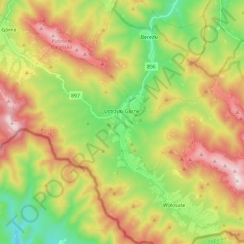
Naam: Topografische kaart Ustrzyki Górne, hoogte, reliëf.
Gemiddelde hoogte: 849 m
Minimale hoogte: 468 m
Maximale hoogte: 1.339 m
Andere topografische kaarten
Klik op een kaart om zijn topografie, zijn hoogte en zijn reliëf te bekijken.
Bieszczady
Poland > Subcarpathian Voivodeship > Bieszczady County > Zatwarnica
Bieszczady, Zatwarnica, gmina Lutowiska, Bieszczady County, Subcarpathian Voivodeship, Poland
Gemiddelde hoogte: 928 m
Chrewt
Poland > Subcarpathian Voivodeship > Bieszczady County > Chrewt
Chrewt, gmina Czarna, Bieszczady County, Subcarpathian Voivodeship, Poland
Gemiddelde hoogte: 465 m
Lutowiska
Poland > Subcarpathian Voivodeship > Bieszczady County
Lutowiska, gmina Lutowiska, Bieszczady County, Subcarpathian Voivodeship, Poland
Gemiddelde hoogte: 649 m