
Topografische kaart Battle Ground
Interactieve kaart
Klik op de kaart om de hoogte weer te geven.
Over deze kaart
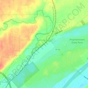
Naam: Topografische kaart Battle Ground, hoogte, reliëf.
Locatie: Battle Ground, Tippecanoe County, Indiana, United States (40.49690 -86.87474 40.51664 -86.82860)
Gemiddelde hoogte: 180 m
Minimale hoogte: 156 m
Maximale hoogte: 208 m
Battle Ground is located at 40°30′36″N 86°50′18″W / 40.51000°N 86.83833°W / 40.51000; -86.83833 (40.510110, −86.838220) in Tippecanoe Township, one and a quarter miles northwest of the Wabash River. Its elevation is approximately 585 feet. The small Harrison Creek begins near Battle Ground and flows east, while Burnett Creek skirts the town's western edge and flows southwest.
Andere topografische kaarten
Klik op een kaart om zijn topografie, zijn hoogte en zijn reliëf te bekijken.
Lafayette
United States > Indiana > Tippecanoe County
Lafayette, Tippecanoe County, Indiana, United States
Gemiddelde hoogte: 193 m
West Lafayette
United States > Indiana > Tippecanoe County
West Lafayette, Tippecanoe County, Indiana, United States
Gemiddelde hoogte: 192 m
Burnett's Creek
United States > Indiana > Tippecanoe County > Battle Ground
Burnett's Creek, Battle Ground, Tippecanoe County, Indiana, United States
Gemiddelde hoogte: 179 m
Altamont Switch
United States > Indiana > Tippecanoe County > Lafayette
Altamont Switch, Lafayette, Tippecanoe County, Indiana, 47909, United States
Gemiddelde hoogte: 197 m
Buck Creek
United States > Indiana > Tippecanoe County
Buck Creek, Tippecanoe County, Indiana, 47924, United States
Gemiddelde hoogte: 202 m
West Point
United States > Indiana > Tippecanoe County
West Point, Tippecanoe County, Indiana, 47992, United States
Gemiddelde hoogte: 198 m