
Topografische kaart Ormond
Interactieve kaart
Klik op de kaart om de hoogte weer te geven.
Over deze kaart
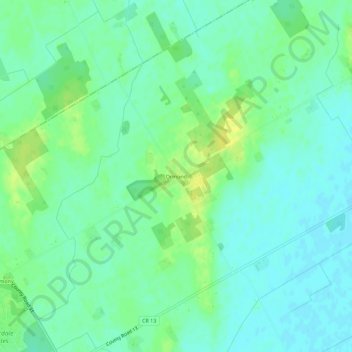
Naam: Topografische kaart Ormond, hoogte, reliëf.
Gemiddelde hoogte: 77 m
Minimale hoogte: 69 m
Maximale hoogte: 89 m
Andere topografische kaarten
Klik op een kaart om zijn topografie, zijn hoogte en zijn reliëf te bekijken.
Timmins Drain
Canada > Ontario > Stormont, Dundas and Glengarry Counties > North Dundas
Timmins Drain, North Dundas, Stormont, Dundas and Glengarry Counties, Eastern Ontario, Ontario, Canada
Gemiddelde hoogte: 72 m
Winchester
Canada > Ontario > Stormont, Dundas and Glengarry Counties > North Dundas
Winchester, North Dundas, Stormont, Dundas and Glengarry Counties, Eastern Ontario, Ontario, K0C 2K0, Canada
Gemiddelde hoogte: 76 m
Hallville
Canada > Ontario > Stormont, Dundas and Glengarry Counties > North Dundas
Hallville, North Dundas, Stormont, Dundas and Glengarry Counties, Eastern Ontario, Ontario, Canada
Gemiddelde hoogte: 91 m
Chesterville
Canada > Ontario > Stormont, Dundas and Glengarry Counties > North Dundas
Chesterville, North Dundas, Stormont, Dundas and Glengarry Counties, Eastern Ontario, Ontario, K0C 1H0, Canada
Gemiddelde hoogte: 74 m