
Topografische kaart Ujjain
Interactieve kaart
Klik op de kaart om de hoogte weer te geven.
Over deze kaart
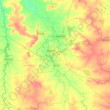
Naam: Topografische kaart Ujjain, hoogte, reliëf.
Gemiddelde hoogte: 501 m
Minimale hoogte: 458 m
Maximale hoogte: 547 m
Ujjain is located in the west-central part of India, and is north of the upper limit of the Vindhya mountain ranges. Located on the Malwa plateau, it is higher than the north Indian plains and the land rises towards the Vindhya Range to the south. Ujjain's co-ordinates are 23°10′N 75°46′E / 23.167°N 75.767°E / 23.167; 75.767 with an average elevation of 494 m (1620 ft). The region is an extension of the Deccan Traps, formed between 60 and 68 million years ago at the end of the Cretaceous period. The city is on the bank of the river Shipra which flows into the nearby Chambal. The tropic of cancer also passes through a temple named Karkoteshwar, located near Harsiddhi Mandir in Ujjain. The Tropic of Cancer is thought to go through 4 parts of Ujjain—The Mangalnath temple, Jantar Mantar, Dome of Mahakal and the Karkrajeshwar temple. Ujjain is geographically situated at a spot where the zero meridian of longitude and the Tropic of Cancer intersect.