
Topografische kaart Curraghmore
Interactieve kaart
Klik op de kaart om de hoogte weer te geven.
Over deze kaart
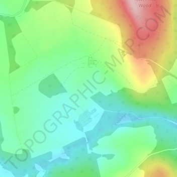
Naam: Topografische kaart Curraghmore, hoogte, reliëf.
Gemiddelde hoogte: 95 m
Minimale hoogte: 22 m
Maximale hoogte: 238 m
Andere topografische kaarten
Klik op een kaart om zijn topografie, zijn hoogte en zijn reliëf te bekijken.
Curraghmore House
Curraghmore House, King John's Bridge, Portlaw, The Municipal District of Comeragh, County Waterford, Munster, Ireland
Gemiddelde hoogte: 88 m
Dromana
Dromana, The Municipal District of Dungarvan — Lismore, County Waterford, Munster, Ireland
Gemiddelde hoogte: 34 m
Kilsheelan Registrars District 1885
Kilsheelan Registrars District 1885, County Waterford, Munster, Ireland
Gemiddelde hoogte: 160 m
The Municipal District of Dungarvan — Lismore
The Municipal District of Dungarvan — Lismore, County Waterford, Munster, Ireland
Gemiddelde hoogte: 120 m
Newtown Cove
Newtown Cove, Islandikane, Waterford City Metropolitan District, County Waterford, Munster, Ireland
Gemiddelde hoogte: 22 m
Skibbereen
Skibbereen, Ballynaneashagh, Waterford City Metropolitan District, County Waterford, Munster, Ireland
Gemiddelde hoogte: 40 m
Ballynaharda
Ballynaharda, Ballymacart, The Municipal District of Dungarvan — Lismore, County Waterford, Munster, Ireland
Gemiddelde hoogte: 50 m
Comeragh
Comeragh, The Municipal District of Comeragh, County Waterford, Munster, Ireland
Gemiddelde hoogte: 215 m
Waterford
Waterford, County Waterford, Munster, Ireland
Gemiddelde hoogte: 33 m
Waterford City Metropolitan District
Waterford City Metropolitan District, County Waterford, Munster, Ireland
Gemiddelde hoogte: 29 m
Tallow
Tallow, The Municipal District of Dungarvan — Lismore, County Waterford, Munster, Ireland
Gemiddelde hoogte: 105 m
Ballymacarbry
Ballymacarbry, The Municipal District of Comeragh, County Waterford, Munster, Ireland
Gemiddelde hoogte: 145 m
Ballyduff
Ballyduff, The Municipal District of Dungarvan — Lismore, County Waterford, Munster, Ireland
Gemiddelde hoogte: 187 m
Tramore
Tramore, Waterford City Metropolitan District, County Waterford, Munster, Ireland
Gemiddelde hoogte: 41 m