
Topografische kaart Kunigal
Interactieve kaart
Klik op de kaart om de hoogte weer te geven.
Over deze kaart
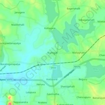
Naam: Topografische kaart Kunigal, hoogte, reliëf.
Gemiddelde hoogte: 775 m
Minimale hoogte: 751 m
Maximale hoogte: 850 m
Kunigal is located at 13°01′N 77°02′E / 13.02°N 77.03°E / 13.02; 77.03. It has an average elevation of 773 metres (2536 feet). It is situated on the National Highway 48 ( NH-48 ) connecting Bangalore and Mangalore and State Highway 33 connecting Tumakuru and Madduru. Recently opened Hassan-Bangalore railway line transverses through Kunigal.
Andere topografische kaarten
Klik op een kaart om zijn topografie, zijn hoogte en zijn reliëf te bekijken.
Sugganahalli
India > Karnataka > Kunigal taluk
Sugganahalli, Kunigal taluk, Tumakuru District, Karnataka, India
Gemiddelde hoogte: 676 m
Ujjani
India > Karnataka > Kunigal taluk
Ujjani, Kunigal taluk, Tumkur district, Karnataka, 572123, India
Gemiddelde hoogte: 717 m