
Topografische kaart Hokitika
Interactieve kaart
Klik op de kaart om de hoogte weer te geven.
Over deze kaart
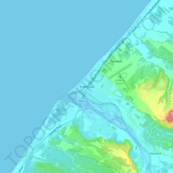
Naam: Topografische kaart Hokitika, hoogte, reliëf.
Locatie: Hokitika, Westland District, West Coast, 7810, New Zealand (-42.75789 170.92465 -42.67789 171.00465)
Gemiddelde hoogte: 14 m
Minimale hoogte: 0 m
Maximale hoogte: 155 m
Andere topografische kaarten
Klik op een kaart om zijn topografie, zijn hoogte en zijn reliëf te bekijken.
Okuru
New Zealand > West Coast > Westland District
Okuru, Westland District, West Coast, New Zealand
Gemiddelde hoogte: 3 m
Gillespies Beach
New Zealand > West Coast > Westland District
Gillespies Beach, Westland District, West Coast, New Zealand
Gemiddelde hoogte: 14 m
Waikowai Stream
New Zealand > West Coast > Westland District
Waikowai Stream, Westland District, West Coast, New Zealand
Gemiddelde hoogte: 13 m
Hooker Glacier
New Zealand > West Coast > Westland District
Hooker Glacier, Westland District, West Coast, New Zealand
Gemiddelde hoogte: 1.930 m
Belmont
New Zealand > West Coast > Westland District
Belmont, Westland District, West Coast, New Zealand
Gemiddelde hoogte: 1.623 m
Haast
New Zealand > West Coast > Westland District
Haast, Westland District, West Coast, New Zealand
Gemiddelde hoogte: 15 m
Fox Glacier
New Zealand > West Coast > Westland District
Fox Glacier, Westland District, West Coast, New Zealand
Gemiddelde hoogte: 1.848 m
Franz Josef
New Zealand > West Coast > Westland District
Franz Josef, Westland District, West Coast, 7856, New Zealand
Gemiddelde hoogte: 277 m
Mount Tasman
New Zealand > West Coast > Westland District
Mount Tasman, Westland District, West Coast, New Zealand
Gemiddelde hoogte: 2.798 m