
Topografische kaart Mentone
Interactieve kaart
Klik op de kaart om de hoogte weer te geven.
Over deze kaart
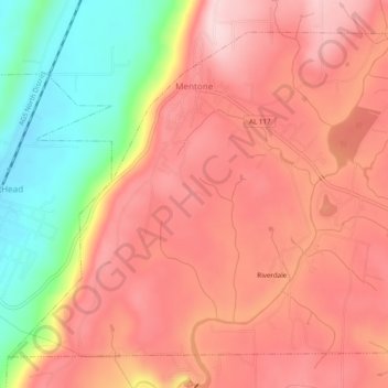
Naam: Topografische kaart Mentone, hoogte, reliëf.
Locatie: Mentone, DeKalb County, Alabama, 35984, United States (34.55162 -85.61387 34.58513 -85.56532)
Gemiddelde hoogte: 470 m
Minimale hoogte: 307 m
Maximale hoogte: 566 m
Mentone is a town in DeKalb County, Alabama, United States. Mentone, located atop Lookout Mountain, has the highest elevation of any incorporated town in Alabama, and narrowly higher than Hytop.
Andere topografische kaarten
Klik op een kaart om zijn topografie, zijn hoogte en zijn reliëf te bekijken.
Fort Payne
United States > Alabama > DeKalb County
Fort Payne, DeKalb County, Alabama, 35967, United States
Gemiddelde hoogte: 369 m
Henagar
United States > Alabama > DeKalb County
Henagar, DeKalb County, Alabama, 35978, United States
Gemiddelde hoogte: 436 m
Mentone
United States > Alabama > DeKalb County
Mentone, DeKalb County, Alabama, 35984, United States
Gemiddelde hoogte: 471 m
Grove Oak
United States > Alabama > DeKalb County
Grove Oak, DeKalb County, Alabama, 35975, United States
Gemiddelde hoogte: 344 m
Hammondville
United States > Alabama > DeKalb County
Hammondville, DeKalb County, Alabama, United States
Gemiddelde hoogte: 362 m
Shiloh
United States > Alabama > DeKalb County
Shiloh, DeKalb County, Alabama, United States
Gemiddelde hoogte: 376 m
Lakeview
United States > Alabama > DeKalb County
Lakeview, DeKalb County, Alabama, United States
Gemiddelde hoogte: 344 m
Valley Head
United States > Alabama > DeKalb County
Valley Head, DeKalb County, Alabama, United States
Gemiddelde hoogte: 410 m
Collinsville
United States > Alabama > DeKalb County
Collinsville, DeKalb County, Alabama, 35961, United States
Gemiddelde hoogte: 285 m
Rainsville
United States > Alabama > DeKalb County
Rainsville, DeKalb County, Alabama, 35986, United States
Gemiddelde hoogte: 380 m
Crossville
United States > Alabama > DeKalb County
Crossville, DeKalb County, Alabama, United States
Gemiddelde hoogte: 337 m
Powell
United States > Alabama > DeKalb County
Powell, DeKalb County, Alabama, United States
Gemiddelde hoogte: 380 m
Geraldine
United States > Alabama > DeKalb County
Geraldine, DeKalb County, Alabama, 35974, United States
Gemiddelde hoogte: 349 m
Fyffe
United States > Alabama > DeKalb County
Fyffe, DeKalb County, Alabama, 35971, United States
Gemiddelde hoogte: 376 m
Pine Ridge
United States > Alabama > DeKalb County
Pine Ridge, DeKalb County, Alabama, United States
Gemiddelde hoogte: 312 m
Desoto State Park
United States > Alabama > DeKalb County > Fort Payne
Desoto State Park, Fort Payne, DeKalb County, Alabama, United States
Gemiddelde hoogte: 454 m
Minvale
United States > Alabama > DeKalb County > Fort Payne > Minvale
Minvale, Fort Payne, DeKalb County, Alabama, 35967, United States
Gemiddelde hoogte: 322 m
Little River Canyon National Preserve
United States > Alabama > DeKalb County > Fort Payne
Little River Canyon National Preserve, Fort Payne, DeKalb County, Alabama, United States
Gemiddelde hoogte: 328 m
Collinsville
United States > Alabama > DeKalb County > Collinsville
Collinsville, DeKalb County, Alabama, 35961, United States
Gemiddelde hoogte: 285 m
Fort Payne
United States > Alabama > DeKalb County > Fort Payne
Fort Payne, DeKalb County, Alabama, 35967, United States
Gemiddelde hoogte: 350 m
Ider
United States > Alabama > DeKalb County
Ider, DeKalb County, Alabama, United States
Gemiddelde hoogte: 467 m
Red Hill
United States > Alabama > DeKalb County
Red Hill, DeKalb County, Alabama, United States
Gemiddelde hoogte: 255 m
Sylvania
United States > Alabama > DeKalb County
Sylvania, DeKalb County, Alabama, 35988, United States
Gemiddelde hoogte: 405 m