
Doe een donatie
Rust jezelf uit voor je volgende avontuur:
Als Amazon-partner verdient deze site een commissie op in aanmerking komende aankopen, zonder extra kosten voor jou.
Topografische kaart Hiva Oa
Klik op de kaart om de hoogte weer te geven.
Doe een donatie
Rust jezelf uit voor je volgende avontuur:
Als Amazon-partner verdient deze site een commissie op in aanmerking komende aankopen, zonder extra kosten voor jou.
Hiva Oa
Hiva Oa is the largest and most fertile of the southern Marquesas islands and second only to Nuku Hiva in size. Similar to all the larger Marquesas, Hiva Oa features steep cliffs abruptly rising from the ocean to a rugged interior spine of volcanic mountains, ridges, and deep, isolated valleys. Unlike most other Polynesian islands near the equator, no fringing coral reefs protect Hiva Oa from the pounding of the ocean and only a few sheltered anchorages and sandy beaches are scattered around the coast. Travel along the shoreline is by boat as most of the coastal terrain is too rugged for roads. A few dirt roads traverse the interior and link seacoast villages and settlements. Atuona Airport is located at an elevation of 1,481 feet (451 m) on a plateau near the center of the island and has an asphalt-surfaced runway 3,986 feet (1,215 m) long with daily flights to other Marquesas islands and Tahiti.
Doe een donatie
Rust jezelf uit voor je volgende avontuur:
Als Amazon-partner verdient deze site een commissie op in aanmerking komende aankopen, zonder extra kosten voor jou.
Over deze kaart
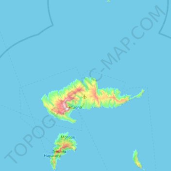
Naam: Topografische kaart Hiva Oa, hoogte, reliëf.
Locatie: Hiva Oa, Marquesas Islands, French Polynesia, France (-10.02422 -139.16389 -9.43299 -138.79678)
Gemiddelde hoogte: 31 m
Minimale hoogte: -7 m
Maximale hoogte: 1.249 m
Doe een donatie
Rust jezelf uit voor je volgende avontuur:
Als Amazon-partner verdient deze site een commissie op in aanmerking komende aankopen, zonder extra kosten voor jou.