
Topografische kaart Zacatelco
Interactieve kaart
Klik op de kaart om de hoogte weer te geven.
Zacatelco
Zacatelco is located in the southern part of the valley of Tlaxcala, on the border with the state of Puebla, is at an altitude of 2,210 meters above sea level, making it one of the highest cities in Mexico. It is located just 11.9 km from the state capital, 27.1 km from the city of Puebla and 121.8 km from Mexico City.
Over deze kaart
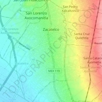
Naam: Topografische kaart Zacatelco, hoogte, reliëf.
Locatie: Zacatelco, Tlaxcala, Mexico (19.17436 -98.26083 19.23270 -98.23024)
Gemiddelde hoogte: 2.215 m
Minimale hoogte: 2.181 m
Maximale hoogte: 2.278 m