
Topografische kaart Montpelier
Interactieve kaart
Klik op de kaart om de hoogte weer te geven.
Over deze kaart
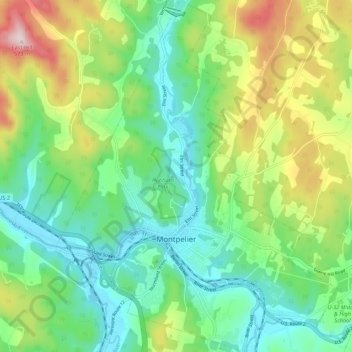
Naam: Topografische kaart Montpelier, hoogte, reliëf.
Locatie: Montpelier, Washington County, Vermont, 05602, United States (44.23492 -72.61245 44.31331 -72.52509)
Gemiddelde hoogte: 284 m
Minimale hoogte: 152 m
Maximale hoogte: 564 m
Montpelier is located in the north-central area of Vermont. The city center is a flat clay zone (elevation 520 ft; 160 m), surrounded by hills and granite ledges. Towne Hill runs in a 2-mile (3.2 km) ridge (~900 ft; 270 m) along the northern edge of the city.
Andere topografische kaarten
Klik op een kaart om zijn topografie, zijn hoogte en zijn reliëf te bekijken.
Waitsfield
United States > Vermont > Washington County
Waitsfield, Washington County, Vermont, United States
Gemiddelde hoogte: 424 m
Waterbury
United States > Vermont > Washington County > Waterbury
Waterbury, Washington County, Vermont, United States
Gemiddelde hoogte: 199 m
Worcester
United States > Vermont > Washington County
Worcester, Washington County, Vermont, 05682, United States
Gemiddelde hoogte: 461 m
Fayston
United States > Vermont > Washington County
Fayston, Washington County, Vermont, United States
Gemiddelde hoogte: 504 m
Middlesex
United States > Vermont > Washington County > Middlesex
Middlesex, Washington County, Vermont, United States
Gemiddelde hoogte: 330 m
Calais
United States > Vermont > Washington County > Calais
Calais, Washington County, Vermont, United States
Gemiddelde hoogte: 363 m
South Cabot
United States > Vermont > Washington County > Cabot > South Cabot
South Cabot, Cabot, Washington County, Vermont, 05647, United States
Gemiddelde hoogte: 480 m
Northfield
United States > Vermont > Washington County > Northfield
Northfield, Washington County, Vermont, 05663, United States
Gemiddelde hoogte: 298 m