
Topografische kaart Mount Barker
Interactieve kaart
Klik op de kaart om de hoogte weer te geven.
Over deze kaart
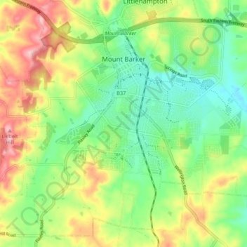
Naam: Topografische kaart Mount Barker, hoogte, reliëf.
Gemiddelde hoogte: 368 m
Minimale hoogte: 302 m
Maximale hoogte: 467 m
Mount Barker is located on the plains surrounding the Mount Barker Summit, about 2 km west of the mountain itself, at 35°04′S 138°51′E / 35.067°S 138.850°E / -35.067; 138.850. Mount Barker is south east of Mount Lofty and Adelaide. It is to the north of The Coorong, and the west of Murray Bridge. Mount Barker is at an elevation of 360 m.