
Topografische kaart Vyšná Rybnica
Interactieve kaart
Klik op de kaart om de hoogte weer te geven.
Over deze kaart
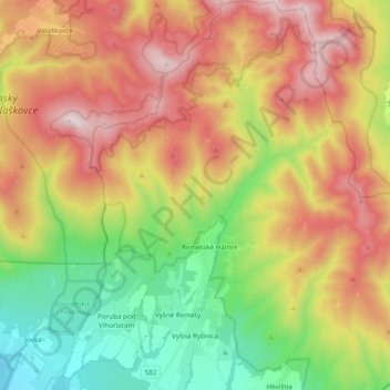
Naam: Topografische kaart Vyšná Rybnica, hoogte, reliëf.
Gemiddelde hoogte: 538 m
Minimale hoogte: 109 m
Maximale hoogte: 1.047 m
The village lies at an altitude of 222 metres and covers an area of 40.082 km². It has a population of 375 people.
Andere topografische kaarten
Klik op een kaart om zijn topografie, zijn hoogte en zijn reliëf te bekijken.
Sobrance
Slovakia > Region of Košice > District of Sobrance
Sobrance, District of Sobrance, Region of Košice, Eastern Slovakia, 073 01, Slovakia
Gemiddelde hoogte: 124 m