
Topografische kaart Nové Zámky
Interactieve kaart
Klik op de kaart om de hoogte weer te geven.
Over deze kaart
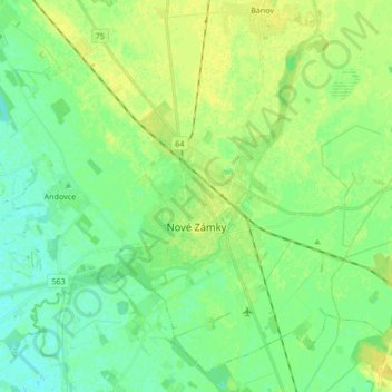
Naam: Topografische kaart Nové Zámky, hoogte, reliëf.
Gemiddelde hoogte: 116 m
Minimale hoogte: 108 m
Maximale hoogte: 126 m
The town is located on the Danubian Lowland, on the Nitra River, at an altitude of 119 metres. It is located around 100 km from Bratislava and around 25 km from the Hungarian border. It is a road and railway hub of southern Slovakia.
Andere topografische kaarten
Klik op een kaart om zijn topografie, zijn hoogte en zijn reliëf te bekijken.
Rastislavice
Slovakia > Region of Nitra > District of Nové Zámky
Rastislavice, District of Nové Zámky, Region of Nitra, Western Slovakia, 941 08, Slovakia
Gemiddelde hoogte: 125 m
Strekov
Slovakia > Region of Nitra > District of Nové Zámky
Strekov, District of Nové Zámky, Region of Nitra, Western Slovakia, 941 37, Slovakia
Gemiddelde hoogte: 163 m
Štúrovo
Slovakia > Region of Nitra > District of Nové Zámky
Štúrovo, District of Nové Zámky, Region of Nitra, Western Slovakia, Slovakia
Gemiddelde hoogte: 115 m