
Topografische kaart Dr Ruth Segomotsi Mompati District Municipality
Interactieve kaart
Klik op de kaart om de hoogte weer te geven.
Over deze kaart
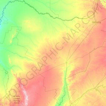
Naam: Topografische kaart Dr Ruth Segomotsi Mompati District Municipality, hoogte, reliëf.
Gemiddelde hoogte: 1.234 m
Minimale hoogte: 976 m
Maximale hoogte: 1.854 m
Andere topografische kaarten
Klik op een kaart om zijn topografie, zijn hoogte en zijn reliëf te bekijken.
Rustenburg Local Municipality
RSA > North West > Rustenburg Local Municipality
Rustenburg Local Municipality, Bojanala Platinum District Municipality, North West, 0322, RSA
Gemiddelde hoogte: 1.287 m
Brits
RSA > North West > Brits
Brits, Bojanala Platinum District Municipality, North West, 0250, RSA
Gemiddelde hoogte: 1.120 m
Tlokwe Ward 2
RSA > North West > Tlokwe Local Municipality
Tlokwe Ward 2, Tlokwe Local Municipality, Dr Kenneth Kaunda District Municipality, North West, 2191, RSA
Gemiddelde hoogte: 1.426 m
Brooksby
RSA > North West > Brooksby
Brooksby, Ngaka Modiri Molema District Municipality, North West, RSA
Gemiddelde hoogte: 1.377 m