
Topografische kaart Lambley Lane Recreation Ground (North)
Interactieve kaart
Klik op de kaart om de hoogte weer te geven.
Over deze kaart
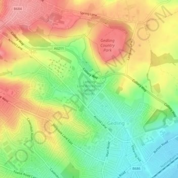
Naam: Topografische kaart Lambley Lane Recreation Ground (North), hoogte, reliëf.
Gemiddelde hoogte: 73 m
Minimale hoogte: 21 m
Maximale hoogte: 124 m
Andere topografische kaarten
Klik op een kaart om zijn topografie, zijn hoogte en zijn reliëf te bekijken.
Colwick Country Park
United Kingdom > England > Nottinghamshire > Gedling > Carlton > Colwick
Colwick Country Park, Colwick, Carlton, Gedling, Nottinghamshire, England, NG4 2EW, United Kingdom
Gemiddelde hoogte: 32 m
Carlton
United Kingdom > England > Nottinghamshire > Gedling > Carlton
Carlton, Gedling, Nottinghamshire, East Midlands, England, NG4 1SR, United Kingdom
Gemiddelde hoogte: 51 m