
Topografische kaart Sękowo
Interactieve kaart
Klik op de kaart om de hoogte weer te geven.
Over deze kaart
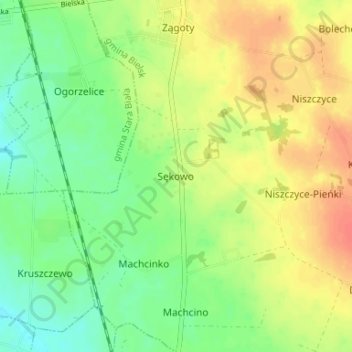
Naam: Topografische kaart Sękowo, hoogte, reliëf.
Gemiddelde hoogte: 128 m
Minimale hoogte: 107 m
Maximale hoogte: 150 m
Andere topografische kaarten
Klik op een kaart om zijn topografie, zijn hoogte en zijn reliëf te bekijken.
Włóki
Poland > Masovian Voivodeship > Płock County
Włóki, gmina Bulkowo, Płock County, Masovian Voivodeship, 09-454, Poland
Gemiddelde hoogte: 129 m
Trzebuń
Poland > Masovian Voivodeship > Płock County > Trzebuń
Trzebuń, gmina Stara Biała, Płock County, Masovian Voivodeship, Poland
Gemiddelde hoogte: 119 m
Małachowo
Poland > Masovian Voivodeship > Płock County > Małachowo
Małachowo, gmina Drobin, Płock County, Masovian Voivodeship, 09-210, Poland
Gemiddelde hoogte: 136 m
Płock
Poland > Masovian Voivodeship > Płock County
Płock, Płock County, Masovian Voivodeship, Poland
Gemiddelde hoogte: 87 m