
Topografische kaart Manning
Interactieve kaart
Klik op de kaart om de hoogte weer te geven.
Over deze kaart
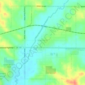
Naam: Topografische kaart Manning, hoogte, reliëf.
Locatie: Manning, Carroll County, Iowa, United States (41.89571 -95.08538 41.92112 -95.04568)
Gemiddelde hoogte: 415 m
Minimale hoogte: 398 m
Maximale hoogte: 448 m
Andere topografische kaarten
Klik op een kaart om zijn topografie, zijn hoogte en zijn reliëf te bekijken.
Willey
United States > Iowa > Carroll County
Willey, Carroll County, Iowa, United States
Gemiddelde hoogte: 390 m
Templeton
United States > Iowa > Carroll County
Templeton, Carroll County, Iowa, United States
Gemiddelde hoogte: 434 m
Middle Raccoon River
United States > Iowa > Carroll County > Carroll
Middle Raccoon River, Rolling Hills, Carroll, Carroll County, Iowa, 51401, United States
Gemiddelde hoogte: 385 m
Ralston
United States > Iowa > Carroll County > Ralston
Ralston, Carroll County, Iowa, 51459, United States
Gemiddelde hoogte: 342 m
Dedham
United States > Iowa > Carroll County
Dedham, Carroll County, Iowa, United States
Gemiddelde hoogte: 395 m