
Topografische kaart Red Wing
Interactieve kaart
Klik op de kaart om de hoogte weer te geven.
Over deze kaart
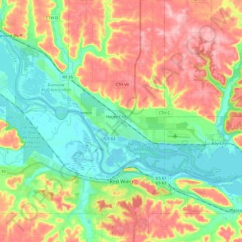
Naam: Topografische kaart Red Wing, hoogte, reliëf.
Locatie: Red Wing, Goodhue County, Minnesota, United States (44.52796 -92.67277 44.66966 -92.46723)
Gemiddelde hoogte: 263 m
Minimale hoogte: 199 m
Maximale hoogte: 353 m
According to the United States Census Bureau, the city has an area of 41.19 square miles (106.68 km2), of which 34.60 square miles (89.61 km2) is land and 6.59 square miles (17.07 km2) is water. The city is at the northern edge of the Driftless Area of karst topography.
Andere topografische kaarten
Klik op een kaart om zijn topografie, zijn hoogte en zijn reliëf te bekijken.
Woodbury WMA
United States > Minnesota > Goodhue County > Zumbrota
Woodbury WMA, 460th Street, Zumbrota, Minneola Township, Goodhue County, Minnesota, 55946, United States
Gemiddelde hoogte: 341 m
Florence Township
United States > Minnesota > Goodhue County
Florence Township, Goodhue County, Minnesota, 55026, United States
Gemiddelde hoogte: 266 m
Welch
United States > Minnesota > Goodhue County
Welch, Goodhue County, Minnesota, 55089, United States
Gemiddelde hoogte: 277 m
Pine Island
United States > Minnesota > Goodhue County
Pine Island, Goodhue County, Minnesota, United States
Gemiddelde hoogte: 327 m
Cannon Falls
United States > Minnesota > Goodhue County > Cannon Falls > Cannon Falls
Cannon Falls, Goodhue County, Minnesota, 55009, United States
Gemiddelde hoogte: 268 m