
Topografische kaart Maywood
Interactieve kaart
Klik op de kaart om de hoogte weer te geven.
Over deze kaart
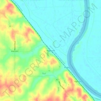
Naam: Topografische kaart Maywood, hoogte, reliëf.
Gemiddelde hoogte: 246 m
Minimale hoogte: 224 m
Maximale hoogte: 288 m
Andere topografische kaarten
Klik op een kaart om zijn topografie, zijn hoogte en zijn reliëf te bekijken.
Leavenworth
United States > Kansas > Leavenworth County > Leavenworth > Leavenworth
Leavenworth, Leavenworth County, Kansas, United States
Gemiddelde hoogte: 268 m
Fort Leavenworth
United States > Kansas > Leavenworth County > Leavenworth > Leavenworth
Fort Leavenworth, Leavenworth, Leavenworth County, Kansas, 66027, United States
Gemiddelde hoogte: 252 m