
Topografische kaart Marshall
Interactieve kaart
Klik op de kaart om de hoogte weer te geven.
Over deze kaart
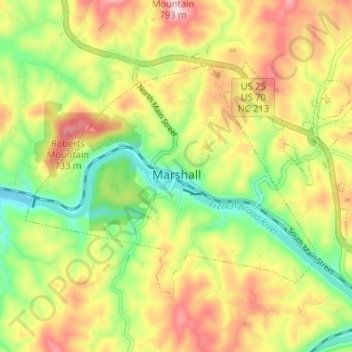
Naam: Topografische kaart Marshall, hoogte, reliëf.
Locatie: Marshall, Madison County, North Carolina, United States (35.77862 -82.71188 35.81582 -82.64689)
Gemiddelde hoogte: 609 m
Minimale hoogte: 483 m
Maximale hoogte: 749 m
Andere topografische kaarten
Klik op een kaart om zijn topografie, zijn hoogte en zijn reliëf te bekijken.
Hot Springs
United States > North Carolina > Madison County
Hot Springs, Madison County, North Carolina, United States
Gemiddelde hoogte: 569 m
Barnard
United States > North Carolina > Madison County
Barnard, Madison County, North Carolina, United States
Gemiddelde hoogte: 601 m
Mars Hill
United States > North Carolina > Madison County > Mars Hill
Mars Hill, Madison County, North Carolina, United States
Gemiddelde hoogte: 708 m
Hot Springs
United States > North Carolina > Madison County > Hot Springs
Hot Springs, Madison County, North Carolina, United States
Gemiddelde hoogte: 641 m