
Topografische kaart Rivercliff
Interactieve kaart
Klik op de kaart om de hoogte weer te geven.
Over deze kaart
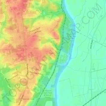
Naam: Topografische kaart Rivercliff, hoogte, reliëf.
Gemiddelde hoogte: 42 m
Minimale hoogte: 14 m
Maximale hoogte: 75 m
Andere topografische kaarten
Klik op een kaart om zijn topografie, zijn hoogte en zijn reliëf te bekijken.
Bordeaux
United States > North Carolina > Cumberland County > Fayetteville
Bordeaux, Fayetteville, Cumberland County, North Carolina, 28248, United States
Gemiddelde hoogte: 59 m
Fenix
United States > North Carolina > Cumberland County > Fayetteville
Fenix, Fayetteville, Cumberland County, North Carolina, 28314, United States
Gemiddelde hoogte: 62 m
Cade Hill
United States > North Carolina > Cumberland County > Fayetteville
Cade Hill, Fayetteville, Cumberland County, North Carolina, United States
Gemiddelde hoogte: 26 m
Atlantic Coastal Plain
United States > North Carolina > Cumberland County > Fayetteville
Atlantic Coastal Plain, Fayetteville, Cumberland County, North Carolina, 28304, United States
Gemiddelde hoogte: 51 m
Blounts Creek
United States > North Carolina > Cumberland County > Fayetteville
Blounts Creek, Fayetteville, Cumberland County, North Carolina, 28301, United States
Gemiddelde hoogte: 29 m
Owens
United States > North Carolina > Cumberland County > Fayetteville > Owens
Owens, Fayetteville, Cumberland County, North Carolina, 28305, United States
Gemiddelde hoogte: 61 m