
Topografische kaart Omu Aran
Interactieve kaart
Klik op de kaart om de hoogte weer te geven.
Over deze kaart
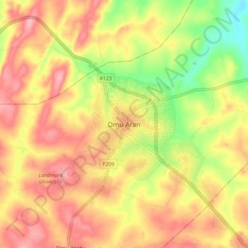
Naam: Topografische kaart Omu Aran, hoogte, reliëf.
Locatie: Omu Aran, Irepodun, Kwara State, 251101, Nigeria (8.09859 5.06133 8.17859 5.14133)
Gemiddelde hoogte: 539 m
Minimale hoogte: 465 m
Maximale hoogte: 592 m
Omu Aran has a tropical wet and dry or savanna climate and is located at an elevation of 536.14 meters (1758.99 feet) above sea level (Classification: Aw). The district's average annual temperature is 0.26% higher than Nigeria's averages at 29.72°C (85.5°F). Omu Aran generally has 149.31 wet days per year (40.91% of the time) and average annual precipitation of roughly 102.08 millimeters (4.02 inches).