
Topografische kaart Lake Waco
Interactieve kaart
Klik op de kaart om de hoogte weer te geven.
Over deze kaart
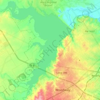
Naam: Topografische kaart Lake Waco, hoogte, reliëf.
Locatie: Lake Waco, Waco, McLennan County, Texas, United States (31.49404 -97.29888 31.61117 -97.18973)
Gemiddelde hoogte: 157 m
Minimale hoogte: 118 m
Maximale hoogte: 223 m
The average elevation of Lake Waco is held around 460 feet above sea level, with a typical fluctuation of 2–6 feet. Prior to the construction of the new dam, droughts and floods were common occurrences for the city of Waco. However, the new dam has proven to be the proper solution, as there has not been any serious floods since its installation. However, a 2011 study from the Texas Water Development Board found that Lake Waco loses between 206-334 acre-feet of capacity every year due to sediment deposition.
Andere topografische kaarten
Klik op een kaart om zijn topografie, zijn hoogte en zijn reliëf te bekijken.
Speegleville
United States > Texas > McLennan County > Waco
Speegleville, Waco, McLennan County, Texas, 76712, United States
Gemiddelde hoogte: 151 m
Waco
United States > Texas > McLennan County > Waco
Waco, McLennan County, Texas, 76701, United States
Gemiddelde hoogte: 150 m
Bosqueville
United States > Texas > McLennan County > Waco > Bosqueville
Bosqueville, Waco, McLennan County, Texas, 76708, United States
Gemiddelde hoogte: 135 m