
Doe een donatie
Rust jezelf uit voor je volgende avontuur:
Als Amazon-partner verdient deze site een commissie op in aanmerking komende aankopen, zonder extra kosten voor jou.
Topografische kaart Carp Lake
Klik op de kaart om de hoogte weer te geven.
Doe een donatie
Rust jezelf uit voor je volgende avontuur:
Als Amazon-partner verdient deze site een commissie op in aanmerking komende aankopen, zonder extra kosten voor jou.
Over deze kaart
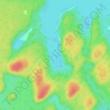
Naam: Topografische kaart Carp Lake, hoogte, reliëf.
Gemiddelde hoogte: 865 m
Minimale hoogte: 841 m
Maximale hoogte: 900 m
Doe een donatie
Rust jezelf uit voor je volgende avontuur:
Als Amazon-partner verdient deze site een commissie op in aanmerking komende aankopen, zonder extra kosten voor jou.
Andere topografische kaarten
Klik op een kaart om zijn topografie, zijn hoogte en zijn reliëf te bekijken.
Summit Lake
Canada > British Columbia > Regional District of Fraser-Fort George > Area G (Crooked River/Parsnip) > Summit Lake
Summit Lake, elevation 710 m (2329 ft), is a lake in the Central Interior of British Columbia, Canada, located to the north of the city of Prince George. It is the namesake of the community of the same name, which lies alongside the John Hart Highway to the south of the community of McLeod Lake (Fort McLeod).…
Gemiddelde hoogte: 729 m
Bear Lake
Canada > British Columbia > Regional District of Fraser-Fort George > Area G (Crooked River/Parsnip)
Gemiddelde hoogte: 726 m
Davie Lake
Canada > British Columbia > Regional District of Fraser-Fort George > Area G (Crooked River/Parsnip)
Gemiddelde hoogte: 718 m
Tacheeda Lakes
Canada > British Columbia > Regional District of Fraser-Fort George > Area G (Crooked River/Parsnip)
Gemiddelde hoogte: 875 m
Doe een donatie
Rust jezelf uit voor je volgende avontuur:
Als Amazon-partner verdient deze site een commissie op in aanmerking komende aankopen, zonder extra kosten voor jou.
McLeod Lake
Canada > British Columbia > Regional District of Fraser-Fort George > Area G (Crooked River/Parsnip)
A point in the marshes on its southern shore of nearby Summit Lake marks the low point of the divide between the drainages of the Fraser and Peace Rivers, As such it is significant as the prominence col between all points south in the Rockies and beyond and their "parent" summits in northern BC and Alaska.…
Gemiddelde hoogte: 701 m