
Topografische kaart Village of Nissequogue
Interactieve kaart
Klik op de kaart om de hoogte weer te geven.
Over deze kaart
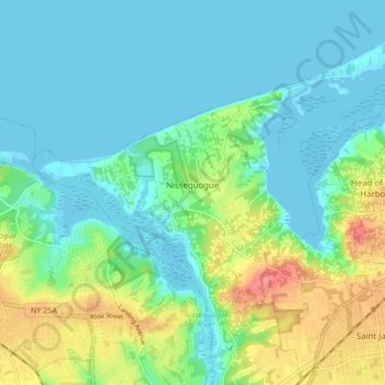
Naam: Topografische kaart Village of Nissequogue, hoogte, reliëf.
Gemiddelde hoogte: 19 m
Minimale hoogte: -1 m
Maximale hoogte: 69 m
Andere topografische kaarten
Klik op een kaart om zijn topografie, zijn hoogte en zijn reliëf te bekijken.
Village of Head of the Harbor
United States > New York > Suffolk County > Town of Smithtown
Village of Head of the Harbor, Town of Smithtown, Suffolk County, New York, United States
Gemiddelde hoogte: 35 m
Nesconset
United States > New York > Suffolk County > Town of Smithtown
Nesconset, Town of Smithtown, Suffolk County, New York, 11767, United States
Gemiddelde hoogte: 31 m
Saint James
United States > New York > Suffolk County > Town of Smithtown
Saint James, Town of Smithtown, Suffolk County, New York, 11780, United States
Gemiddelde hoogte: 39 m