
Topografische kaart Huntley
Interactieve kaart
Klik op de kaart om de hoogte weer te geven.
Over deze kaart
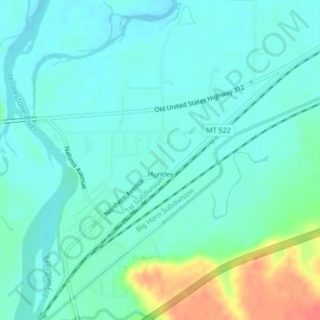
Naam: Topografische kaart Huntley, hoogte, reliëf.
Locatie: Huntley, Yellowstone County, Montana, United States (45.88711 -108.31916 45.91403 -108.29097)
Gemiddelde hoogte: 924 m
Minimale hoogte: 911 m
Maximale hoogte: 965 m
During the Yellowstone Flood of 1937, the damage to Huntley was more extensive, percentage-wise, than in any other community in the region. Much of the original town of Huntley was destroyed and significant portions of the land it occupied was claimed or compromised by the Yellowstone River. The flood damage included washing away the suspension bridge that allowed adjacent Highway 312 to cross the river. After the flood, the site of the town was relocated from the north side of the river to the higher elevation on the south bank.
Andere topografische kaarten
Klik op een kaart om zijn topografie, zijn hoogte en zijn reliëf te bekijken.
Billings
United States > Montana > Yellowstone County
Billings, Yellowstone County, Montana, United States
Gemiddelde hoogte: 1.023 m
Laurel
United States > Montana > Yellowstone County
Laurel, Yellowstone County, Montana, United States
Gemiddelde hoogte: 1.019 m
Yegen
United States > Montana > Yellowstone County
Yegen, Yellowstone County, Montana, United States
Gemiddelde hoogte: 981 m