
Topografische kaart Camelback Mountain
Interactieve kaart
Klik op de kaart om de hoogte weer te geven.
Camelback Mountain
Efforts to protect Camelback Mountain as a natural preserve began in the early 1910s. However, by the 1960s, nearly all of the area had been sold to private interests. Federal and state authorities attempted to stop development above the one thousand and six hundred feet level. They failed to halt development and in 1963 efforts to arrange a land exchange failed in the Arizona State legislature. In 1965, United States Senator Barry Goldwater took up the cause and helped to secure the higher elevations against development. The area became a Phoenix city park in 1968.
Over deze kaart
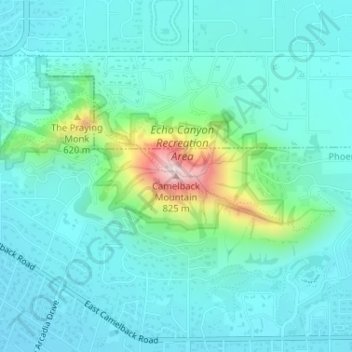
Naam: Topografische kaart Camelback Mountain, hoogte, reliëf.
Gemiddelde hoogte: 462 m
Minimale hoogte: 389 m
Maximale hoogte: 798 m
Andere topografische kaarten
Klik op een kaart om zijn topografie, zijn hoogte en zijn reliëf te bekijken.