
Topografische kaart Live Oak
Interactieve kaart
Klik op de kaart om de hoogte weer te geven.
Over deze kaart
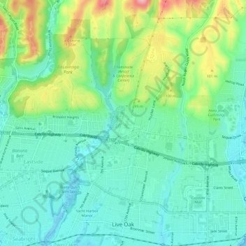
Naam: Topografische kaart Live Oak, hoogte, reliëf.
Locatie: Live Oak, Santa Cruz County, California, United States (36.96743 -122.00111 37.01334 -121.96542)
Gemiddelde hoogte: 47 m
Minimale hoogte: 0 m
Maximale hoogte: 172 m
Live Oak is a census-designated place (CDP) in Santa Cruz County, California between the cities of Santa Cruz and Capitola and north of the former Union Pacific railroad. Live Oak sits at an elevation of 102 feet (31 m). The population was 17,038 at the 2020 census. The population of the greater Live Oak area, including Twin Lakes and Pleasure Point, was 27,921.