
Topografische kaart Bel Aire
Interactieve kaart
Klik op de kaart om de hoogte weer te geven.
Over deze kaart
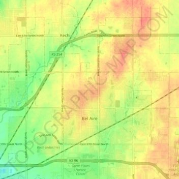
Naam: Topografische kaart Bel Aire, hoogte, reliëf.
Locatie: Bel Aire, Sedgwick County, Kansas, United States (37.75229 -97.28077 37.79596 -97.18976)
Gemiddelde hoogte: 424 m
Minimale hoogte: 396 m
Maximale hoogte: 444 m
Bel Aire is located at 37°45′50″N 97°15′58″W / 37.76389°N 97.26611°W / 37.76389; -97.26611 (37.763758, −97.266177) at an elevation of 1,394 feet (425 m). It lies on the north side of the East Fork of Chisholm Creek roughly 6 mi (9.7 km) northeast of the Arkansas River in the Wellington-McPherson Lowlands region of the Great Plains. Located on the south side of K-254 in south-central Kansas, Bel Aire is within the Wichita metropolitan area, bordered by Wichita to the south and west and bordered by Kechi to the north.
Andere topografische kaarten
Klik op een kaart om zijn topografie, zijn hoogte en zijn reliëf te bekijken.
Wichita
United States > Kansas > Sedgwick County
Wichita, Sedgwick County, Kansas, United States
Gemiddelde hoogte: 408 m
Colwich
United States > Kansas > Sedgwick County
Colwich, Sedgwick County, Kansas, United States
Gemiddelde hoogte: 421 m
Mulvane
United States > Kansas > Sedgwick County
Mulvane, Sedgwick County, Kansas, 67110, United States
Gemiddelde hoogte: 386 m
Wichita
United States > Kansas > Sedgwick County > Wichita
Wichita, Sedgwick County, Kansas, 67202, United States
Gemiddelde hoogte: 410 m
Andale
United States > Kansas > Sedgwick County
Andale, Sedgwick County, Kansas, United States
Gemiddelde hoogte: 440 m
Kechi
United States > Kansas > Sedgwick County
Kechi, Sedgwick County, Kansas, United States
Gemiddelde hoogte: 429 m
Garden Plain
United States > Kansas > Sedgwick County
Garden Plain, Sedgwick County, Kansas, United States
Gemiddelde hoogte: 444 m
Valley Center
United States > Kansas > Sedgwick County
Valley Center, Sedgwick County, Kansas, United States
Gemiddelde hoogte: 413 m
Maize
United States > Kansas > Sedgwick County
Maize, Sedgwick County, Kansas, United States
Gemiddelde hoogte: 414 m
Park City
United States > Kansas > Sedgwick County
Park City, Sedgwick County, Kansas, United States
Gemiddelde hoogte: 421 m
Haysville
United States > Kansas > Sedgwick County
Haysville, Riverside Township, Sedgwick County, Kansas, United States
Gemiddelde hoogte: 388 m
Minneha
United States > Kansas > Sedgwick County > Wichita
Minneha, Wichita, Sedgwick County, Kansas, 67206, United States
Gemiddelde hoogte: 423 m
Valley Center
United States > Kansas > Sedgwick County > Valley Center > Valley Center
Valley Center, Sedgwick County, Kansas, United States
Gemiddelde hoogte: 415 m
Derby
United States > Kansas > Sedgwick County
Derby, Sedgwick County, Kansas, 67037, United States
Gemiddelde hoogte: 393 m
Mount Hope
United States > Kansas > Sedgwick County > Mount Hope
Mount Hope, Sedgwick County, Kansas, United States
Gemiddelde hoogte: 439 m