
Topografische kaart Black Point
Interactieve kaart
Klik op de kaart om de hoogte weer te geven.
Over deze kaart
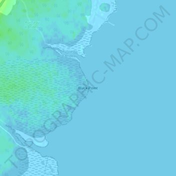
Naam: Topografische kaart Black Point, hoogte, reliëf.
Gemiddelde hoogte: 1 m
Minimale hoogte: -3 m
Maximale hoogte: 10 m
Andere topografische kaarten
Klik op een kaart om zijn topografie, zijn hoogte en zijn reliëf te bekijken.
Tabusintac River
Canada > New Brunswick > Northumberland County
Tabusintac River, Northumberland County, New Brunswick, Canada
Gemiddelde hoogte: 1 m
Glenwood
Canada > New Brunswick > Northumberland County
Glenwood, Glenelg Parish, Northumberland County, New Brunswick, Canada
Gemiddelde hoogte: 39 m
Pineville
Canada > New Brunswick > Northumberland County
Pineville, Blackville Parish, Northumberland County, New Brunswick, Canada
Gemiddelde hoogte: 38 m
Pleasant Ridge
Canada > New Brunswick > Northumberland County
Pleasant Ridge, Rogersville Parish, Northumberland County, New Brunswick, E4Y 2N2, Canada
Gemiddelde hoogte: 89 m
Tilley Ridge
Canada > New Brunswick > Northumberland County
Tilley Ridge, Northesk Parish, Northumberland County, New Brunswick, Canada
Gemiddelde hoogte: 591 m
Priceville
Canada > New Brunswick > Northumberland County
Priceville, Ludlow Parish, Northumberland County, New Brunswick, Canada
Gemiddelde hoogte: 99 m