
Topografische kaart Cadiz City Park
Interactieve kaart
Klik op de kaart om de hoogte weer te geven.
Over deze kaart
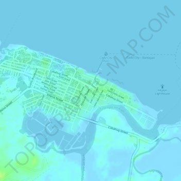
Naam: Topografische kaart Cadiz City Park, hoogte, reliëf.
Gemiddelde hoogte: 2 m
Minimale hoogte: -6 m
Maximale hoogte: 13 m
Andere topografische kaarten
Klik op een kaart om zijn topografie, zijn hoogte en zijn reliëf te bekijken.
Lakawon Island
Philippines > Negros Occidental > Cadiz
Lakawon Island, Cadiz Viejo, Cadiz, Negros Occidental, Western Visayas, Philippines
Gemiddelde hoogte: 0 m
Cadiz
Philippines > Negros Occidental > Cadiz
Cadiz, Negros Occidental, Western Visayas, 6121, Philippines
Gemiddelde hoogte: 68 m
Cadiz
Philippines > Negros Occidental > Cadiz
Cadiz, Negros Occidental, Western Visayas, 6121, Philippines
Gemiddelde hoogte: 116 m