
Topografische kaart Santa Cruz
Interactieve kaart
Klik op de kaart om de hoogte weer te geven.
Over deze kaart
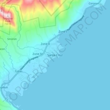
Naam: Topografische kaart Santa Cruz, hoogte, reliëf.
Locatie: Santa Cruz, Davao del Sur, Davao Region, Philippines (6.79406 125.37541 6.87406 125.45541)
Gemiddelde hoogte: 76 m
Minimale hoogte: -5 m
Maximale hoogte: 721 m
Santa Cruz is traversed by mountain ranges and high relief that include part of Mount Apo, the highest mountain peak in the Philippines, straddle the south, central, north and north-western portions of the municipality. The rugged topography of the central area gradually undulates toward the coastal plains of the north-eastern, eastern and south-eastern parts. Here, settlements sprawl contiguously along the coast of Davao Gulf under the vast monotony of coconut plantations. On the western frontier, a plateau stretches toward Barangay Kapatagan of Digos City. The municipal elevation ranges from 10 to 2,939 metres (33 to 9,642 ft) above sea level (m.a.s.1.).