
Topografische kaart Bainbridge Island
Klik op de kaart om de hoogte weer te geven.
Bainbridge Island
Bainbridge Island is characterized by diverse topography shaped by glacial activity during the last Ice Age. The island features gently rolling hills interspersed with flat lowlands and steep coastal bluffs. Elevations range from sea level along the shoreline to about 425 feet at its highest points, with terrain marked by deposits from the Vashon Glaciation, including glacial till and outwash plains. Numerous small valleys and ravines, carved by streams and erosion, crisscross the landscape. The coastline is varied, with rocky promontories, sandy beaches, and tidal inlets, adding to the island’s intricate terrain and natural beauty.
Over deze kaart
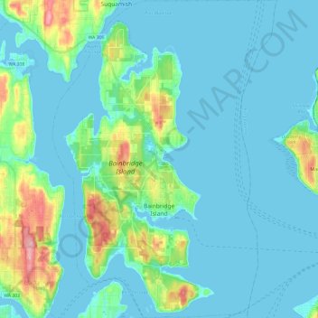
Naam: Topografische kaart Bainbridge Island, hoogte, reliëf.
Gemiddelde hoogte: 24 m
Minimale hoogte: -5 m
Maximale hoogte: 151 m
Andere topografische kaarten
Klik op een kaart om zijn topografie, zijn hoogte en zijn reliëf te bekijken.
Seattle viewpoint
United States > Washington > Kitsap County > Bainbridge Island
Gemiddelde hoogte: 20 m