
Topografische kaart Ituiutaba
Interactieve kaart
Klik op de kaart om de hoogte weer te geven.
Ituiutaba
Ituiutaba (Brazilian Portuguese: /itujuˈtabɐ/) is a municipality in the western part of Minas Gerais state, Brazil. Elevated to city status in 1901, its population in 2020 was 105,255 and a total area in the municipality of 2,694 km2. The elevation of the seat of the municipality is 544 m.
Over deze kaart
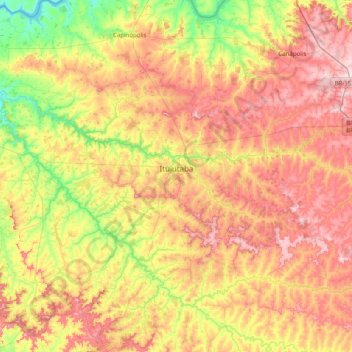
Naam: Topografische kaart Ituiutaba, hoogte, reliëf.
Gemiddelde hoogte: 581 m
Minimale hoogte: 398 m
Maximale hoogte: 795 m