
Topografische kaart Baiyin
Interactieve kaart
Klik op de kaart om de hoogte weer te geven.
Over deze kaart
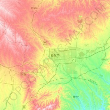
Naam: Topografische kaart Baiyin, hoogte, reliëf.
Locatie: Baiyin, Baiyin District, Baiyin City, Gansu, China (36.38516 103.97554 36.70516 104.29554)
Gemiddelde hoogte: 1.836 m
Minimale hoogte: 1.460 m
Maximale hoogte: 2.239 m
Baiyin is part loess plateau, part desert. Elevation ranges from 1,275 to 3,321 meters (4,183 to 10,896 feet) above sea-level. The climate is very arid with only 110–352 mm (4.3–13.9 in) of annual precipitation. Annual evaporation is 2,101 mm (82.7 in) resulting in a net loss of approximately 1,800 mm (71 in). The Yellow River flows from south to north for 214 km (133 mi) through Baiyin.