
Topografische kaart Yakima
Klik op de kaart om de hoogte weer te geven.
Over deze kaart
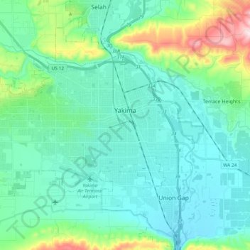
Naam: Topografische kaart Yakima, hoogte, reliëf.
Locatie: Yakima, Yakima County, Washington, United States (46.55729 -120.64449 46.63078 -120.46034)
Gemiddelde hoogte: 377 m
Minimale hoogte: 288 m
Maximale hoogte: 760 m
Andere topografische kaarten
Klik op een kaart om zijn topografie, zijn hoogte en zijn reliëf te bekijken.
Mount Adams
United States > Washington > Yakima County
Adams is one of the long-lived volcanoes in the Cascade Range, with minor activity beginning 900,000 years ago and major cone building activity beginning 520,000 years ago. The whole mountain has been completely eroded by glaciers to an elevation of 8,200 feet (2,500 m) twice during its lifetime. The current…
Gemiddelde hoogte: 3.235 m
Mount Adams
United States > Washington > Yakima County
The mountain is home to diverse ecological zones, ranging from dense lower-elevation forests dominated by Douglas fir and western hemlock on its western slopes to drier ponderosa pine forests on its eastern slopes. These ecosystems support a rich array of flora and fauna, including large mammals like Roosevelt…
Gemiddelde hoogte: 3.235 m
Mount Adams
United States > Washington > Yakima County
Adams is one of the long-lived volcanoes in the Cascade Range, with minor activity beginning 900,000 years ago and major cone building activity beginning 520,000 years ago. The whole mountain has been completely eroded by glaciers to an elevation of 8,200 feet (2,500 m) twice during its lifetime. The current…
Gemiddelde hoogte: 3.235 m