
Topografische kaart Montague Township
Interactieve kaart
Klik op de kaart om de hoogte weer te geven.
Montague Township
Montague Township is a township in Sussex County, in the U.S. state of New Jersey, in the New York City Metropolitan Area. As of the 2020 United States census, the township's population was 3,792, a decrease of 55 (−1.4%) from the 2010 census count of 3,847, which in turn reflected an increase of 435 (+12.7%) from the 3,412 counted in the 2000 census. High Point, within Montague Township, is the highest elevation within New Jersey at an altitude of 1,803 feet (550 m) above sea level. Montague is also the northernmost municipality in the state of New Jersey.
Over deze kaart
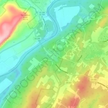
Naam: Topografische kaart Montague Township, hoogte, reliëf.
Locatie: Montague Township, Sussex County, New Jersey, United States (41.28315 -74.81350 41.32315 -74.77350)
Gemiddelde hoogte: 178 m
Minimale hoogte: 104 m
Maximale hoogte: 301 m