
Topografische kaart Theog
Interactieve kaart
Klik op de kaart om de hoogte weer te geven.
Over deze kaart
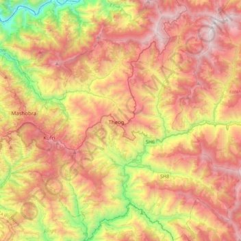
Naam: Topografische kaart Theog, hoogte, reliëf.
Locatie: Theog, Shimla, Himachal Pradesh, India (30.97466 77.26562 31.26835 77.53648)
Gemiddelde hoogte: 1.968 m
Minimale hoogte: 656 m
Maximale hoogte: 3.187 m
Andere topografische kaarten
Klik op een kaart om zijn topografie, zijn hoogte en zijn reliëf te bekijken.
Nani
India > Himachal Pradesh > Theog > Matiana
Nani, Matiana, Theog, Shimla District, Himachal Pradesh, 171212, India
Gemiddelde hoogte: 2.530 m
Kharaban
India > Himachal Pradesh > Theog > Kangar
Kharaban, Kangar, Theog, Shimla District, Himachal Pradesh, India
Gemiddelde hoogte: 2.298 m
Fagu
India > Himachal Pradesh > Theog
Fagu, Theog, Shimla district, Himachal Pradesh, 171209, India
Gemiddelde hoogte: 2.223 m