
Topografische kaart Lantau Island
Interactieve kaart
Klik op de kaart om de hoogte weer te geven.
Over deze kaart
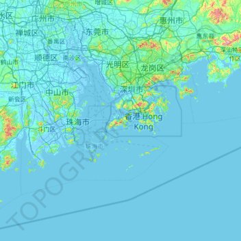
Naam: Topografische kaart Lantau Island, hoogte, reliëf.
Gemiddelde hoogte: 29 m
Minimale hoogte: -6 m
Maximale hoogte: 1.245 m
Andere topografische kaarten
Klik op een kaart om zijn topografie, zijn hoogte en zijn reliëf te bekijken.
Ngong Ping
China > Hong Kong > Islands District > Ngong Ping Village
Ngong Ping, Ngong Ping Village, Islands District, New Territories, Hong Kong, China
Gemiddelde hoogte: 324 m
Airport Channel
China > Hong Kong > Islands District > 黃家圍 > Tin Sam
Airport Channel, Tin Sam, 黃家圍, Islands District, New Territories, Hong Kong, China
Gemiddelde hoogte: 32 m
Tin Sam
China > Hong Kong > Islands District > 黃家圍
Tin Sam, 黃家圍, Islands District, New Territories, Hong Kong, China
Gemiddelde hoogte: 70 m