
Doe een donatie
Rust jezelf uit voor je volgende avontuur:
Als Amazon-partner verdient deze site een commissie op in aanmerking komende aankopen, zonder extra kosten voor jou.
Topografische kaart Dallas
Klik op de kaart om de hoogte weer te geven.
Doe een donatie
Rust jezelf uit voor je volgende avontuur:
Als Amazon-partner verdient deze site een commissie op in aanmerking komende aankopen, zonder extra kosten voor jou.
Dallas
On April 4, 1977, near the site marker for the Battle of New Hope Church, the forced landing of Southern Airways Flight 242 occurred. The passenger jetliner, a McDonnell Douglas DC-9 with 81 passengers and 4 crew members, was flying from Northwest Alabama Regional Airport to Atlanta Municipal Airport. Upon descending in altitude to prepare for landing in Atlanta, the jetliner started to fly through an intense thunderstorm near Rome, Georgia. Because of the extreme amounts of water and hail that were ingested by the jet's engines, both of the Pratt & Whitney JT8D-7A turbojet engines were damaged and underwent flameout. With the engines unable to restart, the flight's crew began gliding in hopes of reaching a nearby airport. Upon finding out that there were no nearby airports to perform a landing, the crew found a straight section of rural road in Dallas, Georgia to try and land. As the plane began to land, it clipped a gas station, convenience store, and other buildings, resulting in the plane to lose control of landing and ultimately crash, resulting in hull loss. Both pilots and 61 passengers were killed by impact forces and fire. Nine people on the ground were also killed.
Doe een donatie
Rust jezelf uit voor je volgende avontuur:
Als Amazon-partner verdient deze site een commissie op in aanmerking komende aankopen, zonder extra kosten voor jou.
Over deze kaart
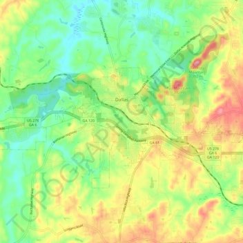
Naam: Topografische kaart Dallas, hoogte, reliëf.
Locatie: Dallas, Paulding County, Georgia, United States (33.88875 -84.89893 33.94127 -84.78327)
Gemiddelde hoogte: 307 m
Minimale hoogte: 252 m
Maximale hoogte: 386 m
Doe een donatie
Rust jezelf uit voor je volgende avontuur:
Als Amazon-partner verdient deze site een commissie op in aanmerking komende aankopen, zonder extra kosten voor jou.
Andere topografische kaarten
Klik op een kaart om zijn topografie, zijn hoogte en zijn reliëf te bekijken.
Doe een donatie
Rust jezelf uit voor je volgende avontuur:
Als Amazon-partner verdient deze site een commissie op in aanmerking komende aankopen, zonder extra kosten voor jou.