Geolokaliseren
👉 Easily get elevation data in JSON, GeoTIFF and KML formats using Elevation API
Bedankt voor het steunen van deze site ❤️
Doe een donatie

Topografische kaart Pullman

Klik op de kaart om de hoogte weer te geven.

👉 Easily get elevation data in JSON, GeoTIFF and KML formats using Elevation API
Bedankt voor het steunen van deze site ❤️
Doe een donatie

Rust jezelf uit voor je volgende avontuur:

Als Amazon-partner verdient deze site een commissie op in aanmerking komende aankopen, zonder extra kosten voor jou.

Pullman

The city is situated across several loess hills which characterize the Palouse Prairie, formed from windblown sediment over an estimated period of over one million years. This prairie region, the Palouse, is noteworthy for its fertile rolling hills where winter and spring wheat, barley, lentils, and peas are grown. These hills provide a variety of elevations across the city, from 2342 to 2575 ft (714 to 785 m) above sea level. Downtown Pullman is situated in a valley between these hills. Within the Pullman city limits, the Missouri Flat Creek and Paradise Creek both join the South Fork of the Palouse River. Pullman sits in the watersheds of the Snake River and the Columbia River.

Over deze kaart

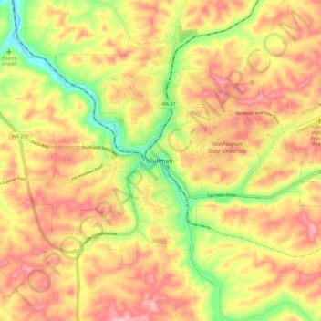
Naam: Topografische kaart Pullman, hoogte, reliëf.

Locatie: Pullman, Whitman County, Washington, 99164-1912, United States (46.69043 -117.21390 46.77043 -117.13390)

Gemiddelde hoogte: 774 m

Minimale hoogte: 693 m

Maximale hoogte: 832 m

Rust jezelf uit voor je volgende avontuur:

🆘EHBO-kits Outdoor - Compacte eerste hulp set voor noodgevallen
Sporthorloges met GPS - Volg je route en hoogteverschillen in real-time
📚Atlassen & Bosatlas - De beste boeken over de topografie van Nederland
🧣Buff Nekwarmers - Veelzijdige bescherming tegen wind en kou
📚Cartografie Boeken - Inzicht in kaartontwerp en kaarten lezen

Als Amazon-partner verdient deze site een commissie op in aanmerking komende aankopen, zonder extra kosten voor jou.