
Doe een donatie
Rust jezelf uit voor je volgende avontuur:
Als Amazon-partner verdient deze site een commissie op in aanmerking komende aankopen, zonder extra kosten voor jou.
Topografische kaart Upper Oddington
Klik op de kaart om de hoogte weer te geven.
Doe een donatie
Rust jezelf uit voor je volgende avontuur:
Als Amazon-partner verdient deze site een commissie op in aanmerking komende aankopen, zonder extra kosten voor jou.
Over deze kaart
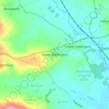
Naam: Topografische kaart Upper Oddington, hoogte, reliëf.
Gemiddelde hoogte: 134 m
Minimale hoogte: 108 m
Maximale hoogte: 223 m
Doe een donatie
Rust jezelf uit voor je volgende avontuur:
Als Amazon-partner verdient deze site een commissie op in aanmerking komende aankopen, zonder extra kosten voor jou.
Andere topografische kaarten
Klik op een kaart om zijn topografie, zijn hoogte en zijn reliëf te bekijken.
Worcestershire (detached)
United Kingdom > England > Gloucestershire > Cotswold District
Gemiddelde hoogte: 103 m
Cirencester Park
United Kingdom > England > Gloucestershire > Cotswold District > Sapperton
Gemiddelde hoogte: 162 m
Cold Aston
United Kingdom > England > Gloucestershire > Cotswold District > Cold Aston
Gemiddelde hoogte: 189 m
Doe een donatie
Rust jezelf uit voor je volgende avontuur:
Als Amazon-partner verdient deze site een commissie op in aanmerking komende aankopen, zonder extra kosten voor jou.
Cirencester
United Kingdom > England > Gloucestershire > Cotswold District
On Cotswold Avenue is the site of a Roman amphitheatre which, while buried, retains its shape in the earthen topography of the small park setting. Cirencester was one of the most substantial cities of Roman-era Britain.
Gemiddelde hoogte: 128 m
South Cerney
United Kingdom > England > Gloucestershire > Cotswold District > South Cerney
Gemiddelde hoogte: 93 m
Doe een donatie
Rust jezelf uit voor je volgende avontuur:
Als Amazon-partner verdient deze site een commissie op in aanmerking komende aankopen, zonder extra kosten voor jou.
Upper Rissington
United Kingdom > England > Gloucestershire > Cotswold District > Upper Rissington
Gemiddelde hoogte: 208 m
Bourton-on-the-Hill
United Kingdom > England > Gloucestershire > Cotswold District
Gemiddelde hoogte: 200 m
Doe een donatie
Rust jezelf uit voor je volgende avontuur:
Als Amazon-partner verdient deze site een commissie op in aanmerking komende aankopen, zonder extra kosten voor jou.
Little Rissington
United Kingdom > England > Gloucestershire > Cotswold District > Little Rissington
Gemiddelde hoogte: 171 m
Coberley
United Kingdom > England > Gloucestershire > Cotswold District > Coberley
Gemiddelde hoogte: 234 m
Doe een donatie
Rust jezelf uit voor je volgende avontuur:
Als Amazon-partner verdient deze site een commissie op in aanmerking komende aankopen, zonder extra kosten voor jou.
Chipping Campden
United Kingdom > England > Gloucestershire > Cotswold District
Gemiddelde hoogte: 191 m
Bibury
United Kingdom > England > Gloucestershire > Cotswold District
The parish is approximately rectangular and stretches far to the rolling, elevated, north. It includes on outlying settlement, Ablington, in the upper valley. Bibury Farm is 300 metres (330 yd) from the village, 151 metres (495 ft) above Ordnance Datum (AOD), which is a similar elevation to much of the north.…
Gemiddelde hoogte: 135 m
Botany Bay Wood
United Kingdom > England > Gloucestershire > Cotswold District > Stow-on-the-Wold
Gemiddelde hoogte: 171 m
Doe een donatie
Rust jezelf uit voor je volgende avontuur:
Als Amazon-partner verdient deze site een commissie op in aanmerking komende aankopen, zonder extra kosten voor jou.
Baunton
United Kingdom > England > Gloucestershire > Cotswold District > Baunton
Gemiddelde hoogte: 146 m
Somerford Keynes
United Kingdom > England > Gloucestershire > Cotswold District > Somerford Keynes
Gemiddelde hoogte: 92 m
Doe een donatie
Rust jezelf uit voor je volgende avontuur:
Als Amazon-partner verdient deze site een commissie op in aanmerking komende aankopen, zonder extra kosten voor jou.
Evenlode
United Kingdom > England > Gloucestershire > Cotswold District > Evenlode
Gemiddelde hoogte: 134 m
Great Rissington
United Kingdom > England > Gloucestershire > Cotswold District > Great Rissington
Gemiddelde hoogte: 168 m
Long Newnton
United Kingdom > England > Gloucestershire > Cotswold District > Long Newnton
Gemiddelde hoogte: 117 m
Doe een donatie
Rust jezelf uit voor je volgende avontuur:
Als Amazon-partner verdient deze site een commissie op in aanmerking komende aankopen, zonder extra kosten voor jou.
Bagendon
United Kingdom > England > Gloucestershire > Cotswold District > Bagendon
Gemiddelde hoogte: 171 m
Didmarton
United Kingdom > England > Gloucestershire > Cotswold District > Didmarton
Gemiddelde hoogte: 147 m
Doe een donatie
Rust jezelf uit voor je volgende avontuur:
Als Amazon-partner verdient deze site een commissie op in aanmerking komende aankopen, zonder extra kosten voor jou.
Daglingworth
United Kingdom > England > Gloucestershire > Cotswold District > Daglingworth
Gemiddelde hoogte: 169 m
Doe een donatie
Rust jezelf uit voor je volgende avontuur:
Als Amazon-partner verdient deze site een commissie op in aanmerking komende aankopen, zonder extra kosten voor jou.
Poulton
United Kingdom > England > Gloucestershire > Cotswold District > Poulton
Gemiddelde hoogte: 109 m
Bourton-on-the-Water
United Kingdom > England > Gloucestershire > Cotswold District
Gemiddelde hoogte: 155 m
Winson
United Kingdom > England > Gloucestershire > Cotswold District > Winson
Gemiddelde hoogte: 145 m
Doe een donatie
Rust jezelf uit voor je volgende avontuur:
Als Amazon-partner verdient deze site een commissie op in aanmerking komende aankopen, zonder extra kosten voor jou.
Windrush
United Kingdom > England > Gloucestershire > Cotswold District > Windrush
Gemiddelde hoogte: 155 m
Sherborne
United Kingdom > England > Gloucestershire > Cotswold District > Sherborne
Gemiddelde hoogte: 156 m
Doe een donatie
Rust jezelf uit voor je volgende avontuur:
Als Amazon-partner verdient deze site een commissie op in aanmerking komende aankopen, zonder extra kosten voor jou.
Elkstone
United Kingdom > England > Gloucestershire > Cotswold District > Elkstone
Gemiddelde hoogte: 234 m
Down Ampney
United Kingdom > England > Gloucestershire > Cotswold District > Down Ampney
Gemiddelde hoogte: 85 m
Hazleton
United Kingdom > England > Gloucestershire > Cotswold District > Hazleton
Gemiddelde hoogte: 227 m
Doe een donatie
Rust jezelf uit voor je volgende avontuur:
Als Amazon-partner verdient deze site een commissie op in aanmerking komende aankopen, zonder extra kosten voor jou.
Chedworth
United Kingdom > England > Gloucestershire > Cotswold District > Chedworth
Gemiddelde hoogte: 187 m
Doe een donatie
Rust jezelf uit voor je volgende avontuur:
Als Amazon-partner verdient deze site een commissie op in aanmerking komende aankopen, zonder extra kosten voor jou.
Fairford
United Kingdom > England > Gloucestershire > Cotswold District > Fairford
Gemiddelde hoogte: 98 m
Moreton-in-Marsh
United Kingdom > England > Gloucestershire > Cotswold District
Gemiddelde hoogte: 135 m
Doe een donatie
Rust jezelf uit voor je volgende avontuur:
Als Amazon-partner verdient deze site een commissie op in aanmerking komende aankopen, zonder extra kosten voor jou.
Bushley Muzzard, Brimpsfield
United Kingdom > England > Gloucestershire > Cotswold District > Nettleton > Watercombe
Gemiddelde hoogte: 261 m
Knap House Quarry, Birdlip
United Kingdom > England > Gloucestershire > Cotswold District > Birdlip
Gemiddelde hoogte: 222 m
Doe een donatie
Rust jezelf uit voor je volgende avontuur:
Als Amazon-partner verdient deze site een commissie op in aanmerking komende aankopen, zonder extra kosten voor jou.
Temple Guiting
United Kingdom > England > Gloucestershire > Cotswold District
Gemiddelde hoogte: 226 m
Cirencester
United Kingdom > England > Gloucestershire > Cotswold District
On Cotswold Avenue is the site of a Roman amphitheatre which, while buried, retains its shape in the earthen topography of the small park setting. Cirencester was one of the most substantial cities of Roman-era Britain.
Gemiddelde hoogte: 128 m
Doe een donatie
Rust jezelf uit voor je volgende avontuur:
Als Amazon-partner verdient deze site een commissie op in aanmerking komende aankopen, zonder extra kosten voor jou.
Didmarton
United Kingdom > England > Gloucestershire > Cotswold District > Didmarton
Gemiddelde hoogte: 147 m
Doe een donatie
Rust jezelf uit voor je volgende avontuur:
Als Amazon-partner verdient deze site een commissie op in aanmerking komende aankopen, zonder extra kosten voor jou.
Cirencester
United Kingdom > England > Gloucestershire > Cotswold District > Chesterton
On Cotswold Avenue is the site of a Roman amphitheatre which, while buried, retains its shape in the earthen topography of the small park setting. Cirencester was one of the most substantial cities of Roman-era Britain.
Gemiddelde hoogte: 128 m
Chipping Campden
United Kingdom > England > Gloucestershire > Cotswold District
Gemiddelde hoogte: 191 m
Cirencester
United Kingdom > England > Gloucestershire > Cotswold District > Chesterton
On Cotswold Avenue is the site of a Roman amphitheatre which, while buried, retains its shape in the earthen topography of the small park setting. Cirencester was one of the most substantial cities of Roman-era Britain.
Gemiddelde hoogte: 128 m
Doe een donatie
Rust jezelf uit voor je volgende avontuur:
Als Amazon-partner verdient deze site een commissie op in aanmerking komende aankopen, zonder extra kosten voor jou.
Cirencester
United Kingdom > England > Gloucestershire > Cotswold District > Chesterton
On Cotswold Avenue is the site of a Roman amphitheatre which, while buried, retains its shape in the earthen topography of the small park setting. Cirencester was one of the most substantial cities of Roman-era Britain.
Gemiddelde hoogte: 128 m