
Topografische kaart Cedar Hill
Interactieve kaart
Klik op de kaart om de hoogte weer te geven.
Over deze kaart
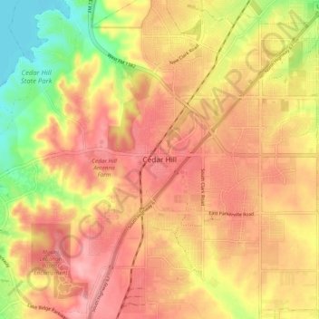
Naam: Topografische kaart Cedar Hill, hoogte, reliëf.
Locatie: Cedar Hill, Dallas County, Texas, 75104-2135, United States (32.54881 -96.99537 32.62881 -96.91537)
Gemiddelde hoogte: 225 m
Minimale hoogte: 156 m
Maximale hoogte: 268 m
It is sometimes referred to as the "hill country of Dallas" (in comparison to the "hill country" surrounding Austin and San Antonio). The city is full of native eastern red cedar evergreen trees and stands at an elevation of about 800 feet (240 m) above sea level—the highest point in a straight line from the Red River at the Texas-Oklahoma border to the Gulf Coast.