
Topografische kaart Rye Creek
Interactieve kaart
Klik op de kaart om de hoogte weer te geven.
Over deze kaart
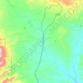
Naam: Topografische kaart Rye Creek, hoogte, reliëf.
Locatie: Rye Creek, Gila County, Arizona, United States (34.02786 -111.42715 34.16651 -111.28534)
Gemiddelde hoogte: 1.093 m
Minimale hoogte: 819 m
Maximale hoogte: 1.991 m
Andere topografische kaarten
Klik op een kaart om zijn topografie, zijn hoogte en zijn reliëf te bekijken.
Payson
United States > Arizona > Gila County
Payson, Gila County, Arizona, 85072, United States
Gemiddelde hoogte: 1.522 m
Globe
United States > Arizona > Gila County
Globe, Gila County, Arizona, 85532, United States
Gemiddelde hoogte: 1.173 m
Star Valley
United States > Arizona > Gila County
Star Valley, Gila County, Arizona, United States
Gemiddelde hoogte: 1.509 m
See Canyon Summer Homes
United States > Arizona > Gila County
See Canyon Summer Homes, Gila County, Arizona, United States
Gemiddelde hoogte: 1.920 m
Rye
United States > Arizona > Gila County
Rye, Gila County, Arizona, United States
Gemiddelde hoogte: 1.008 m
Jakes Corner
United States > Arizona > Gila County
Jakes Corner, Gila County, Arizona, United States
Gemiddelde hoogte: 916 m
Hayden
United States > Arizona > Gila County
Hayden, Gila County, Arizona, United States
Gemiddelde hoogte: 628 m
Peridot
United States > Arizona > Gila County
Peridot, Gila County, Arizona, 85542, United States
Gemiddelde hoogte: 820 m
Winkelman
United States > Arizona > Gila County
Winkelman, Gila County, Arizona, United States
Gemiddelde hoogte: 607 m
Tonto National Monument
United States > Arizona > Gila County
Tonto National Monument, Apache Trail, Gila County, Arizona, 85545, United States
Gemiddelde hoogte: 859 m
Quartsite Tank
United States > Arizona > Gila County
Quartsite Tank, Gila County, Arizona, United States
Gemiddelde hoogte: 1.416 m
Theodore Roosevelt Lake
United States > Arizona > Gila County
Theodore Roosevelt Lake, Gila County, Arizona, United States
Gemiddelde hoogte: 912 m
Punkin Center
United States > Arizona > Gila County
Punkin Center, Gila County, Arizona, 85553, United States
Gemiddelde hoogte: 742 m
Roosevelt
United States > Arizona > Gila County
Roosevelt, Gila County, Arizona, 85545, United States
Gemiddelde hoogte: 733 m
Gisela
United States > Arizona > Gila County
Gisela, Gila County, Arizona, 85541, United States
Gemiddelde hoogte: 957 m
San Carlos
United States > Arizona > Gila County > San Carlos > Peridot
San Carlos, Peridot, Gila County, Arizona, United States
Gemiddelde hoogte: 860 m
Strawberry
United States > Arizona > Gila County
Strawberry, Gila County, Arizona, 85544, United States
Gemiddelde hoogte: 1.889 m
Payson town limits
United States > Arizona > Gila County
Payson town limits, Gila County, Arizona, 85072, United States
Gemiddelde hoogte: 1.522 m
Pine
United States > Arizona > Gila County
Pine, Gila County, Arizona, 85544, United States
Gemiddelde hoogte: 1.794 m
Walnut Canyon
United States > Arizona > Gila County
Walnut Canyon, Gila County, Arizona, United States
Gemiddelde hoogte: 1.299 m
Globe
United States > Arizona > Gila County > Globe
Globe, Gila County, Arizona, 85501, United States
Gemiddelde hoogte: 1.151 m
Young
United States > Arizona > Gila County
Young, Gila County, Arizona, 85554, United States
Gemiddelde hoogte: 1.684 m
Polles Mesa
United States > Arizona > Gila County
Polles Mesa, Gila County, Arizona, United States
Gemiddelde hoogte: 1.280 m
Miami
United States > Arizona > Gila County > Miami
Miami, Gila County, Arizona, 85539, United States
Gemiddelde hoogte: 1.121 m
Copper Hill
United States > Arizona > Gila County
Copper Hill, Gila County, Arizona, 85501, United States
Gemiddelde hoogte: 1.260 m
Tonto Basin
United States > Arizona > Gila County
Tonto Basin, Gila County, Arizona, United States
Gemiddelde hoogte: 887 m
Mountain Meadow
United States > Arizona > Gila County
Mountain Meadow, Gila County, Arizona, United States
Gemiddelde hoogte: 1.906 m