
Topografische kaart Jingpo Lake
Interactieve kaart
Klik op de kaart om de hoogte weer te geven.
Over deze kaart
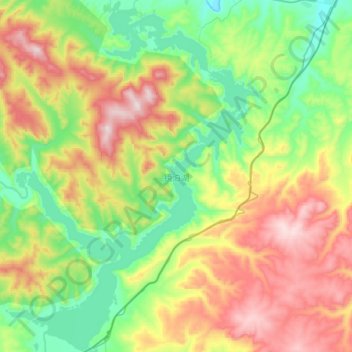
Naam: Topografische kaart Jingpo Lake, hoogte, reliëf.
Gemiddelde hoogte: 523 m
Minimale hoogte: 290 m
Maximale hoogte: 909 m
In the southern side of the lake, there are river deltas formed in the estuary of Mudan River and its tributaries. This topography supports a large number of plankton to survive, so it is suitable for the growth of fish. There are various kinds of freshwater fish in Jingpo Lake. The most famous one is Red-tailed fish, also known as White Cloud Mountain minnow (Tanichthys albonubes).