
Topografische kaart Newton
Interactieve kaart
Klik op de kaart om de hoogte weer te geven.
Newton
Newton has grown around a formation of seven hills. "The general features of Newton are not without interest. Seven principal elevations mark its surface, like the seven hills of ancient Rome, with the difference that the seven hills of Newton are much more distinct than the seven hills of Rome: Nonantum Hill, Waban Hill, Chestnut Hill, Bald Pate, Oak Hill, Institution Hill and Mount Ida."
Over deze kaart
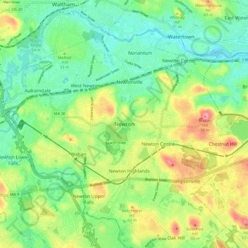
Naam: Topografische kaart Newton, hoogte, reliëf.
Gemiddelde hoogte: 43 m
Minimale hoogte: -3 m
Maximale hoogte: 186 m
Andere topografische kaarten
Klik op een kaart om zijn topografie, zijn hoogte en zijn reliëf te bekijken.