
Topografische kaart Andover
Interactieve kaart
Klik op de kaart om de hoogte weer te geven.
Over deze kaart
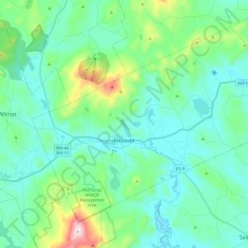
Naam: Topografische kaart Andover, hoogte, reliëf.
Locatie: Andover, Merrimack County, New Hampshire, United States (43.38902 -71.89415 43.50299 -71.69456)
Gemiddelde hoogte: 301 m
Minimale hoogte: 164 m
Maximale hoogte: 886 m
According to the United States Census Bureau, the town has a total area of 41.4 square miles (107.3 km2), of which 40.5 sq mi (105.0 km2) is land and 0.89 sq mi (2.3 km2) is water, comprising 2.14% of the town. Andover is drained by the Blackwater River. Bradley Lake is in the south. Ragged Mountain, elevation 2,286 feet (697 m) above sea level, is on the northern boundary. The northern slopes of Mount Kearsarge occupy the southernmost part of town and contain the town's highest point, 2,460 ft (750 m) above sea level. Andover lies fully within the Merrimack River watershed.