
Topografische kaart Sassafras Mountain
Interactieve kaart
Klik op de kaart om de hoogte weer te geven.
Over deze kaart
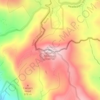
Naam: Topografische kaart Sassafras Mountain, hoogte, reliëf.
Gemiddelde hoogte: 895 m
Minimale hoogte: 624 m
Maximale hoogte: 1.071 m
The Pisgah Quadrangle topographical map, revised 1904–1905, shows the long abandoned Sassafras Gap Road to be the preferred route through to Rosman, N.C. and Brevard, N.C. at the end of the 19th century and that the existing Highway 178 was then a secondary road. This abandoned road is a short distance from the summit and is crossed by the hiking trail to Caesars Head from Sassafras summit. Most people crossing this old roadbed in Sassafras Gap don't recognize it as a road, but it is easily recognized because of the short section of steps going down into the roadbed, and a similar section of short steps on the opposite side of the roadbed going up and the trail then continuing steeply up toward Caesars Head. A short hike South down the old Sassafras Gap Road will take you to Hickory Head Spring, the headwater of the South Saluda River. Hickory Head Spring is shown as a feature on the Mill's Atlas, 1825, Greenville District, South Carolina.
Andere topografische kaarten
Klik op een kaart om zijn topografie, zijn hoogte en zijn reliëf te bekijken.
Berkeley Forest
United States > South Carolina > Pickens County > Clemson
Berkeley Forest, Clemson, Pickens County, South Carolina, 29631, United States
Gemiddelde hoogte: 239 m
Six Mile
United States > South Carolina > Pickens County
Six Mile, Pickens County, South Carolina, United States
Gemiddelde hoogte: 306 m
Wyatt Acres
United States > South Carolina > Pickens County > Easley
Wyatt Acres, Easley, Pickens County, South Carolina, 29642, United States
Gemiddelde hoogte: 298 m
Table Rock Reservoir
United States > South Carolina > Pickens County
Table Rock Reservoir, Pickens County, South Carolina, United States
Gemiddelde hoogte: 477 m
Quail Haven
United States > South Carolina > Pickens County
Quail Haven, Pickens County, South Carolina, United States
Gemiddelde hoogte: 268 m
Liberty
United States > South Carolina > Pickens County
Liberty, Pickens County, South Carolina, United States
Gemiddelde hoogte: 290 m
Pickens
United States > South Carolina > Pickens County > Pickens
Pickens, Pickens County, South Carolina, United States
Gemiddelde hoogte: 315 m
Arial
United States > South Carolina > Pickens County > Arial
Arial, Pickens County, South Carolina, 29641, United States
Gemiddelde hoogte: 319 m
Clemson Heights
United States > South Carolina > Pickens County > Clemson > Clemson Heights
Clemson Heights, Clemson, Pickens County, South Carolina, 29634-5365, United States
Gemiddelde hoogte: 217 m
Easley
United States > South Carolina > Pickens County > Easley
Easley, Pickens County, South Carolina, 29642, United States
Gemiddelde hoogte: 301 m
Clemson
United States > South Carolina > Pickens County
Clemson, Pickens County, South Carolina, 29631, United States
Gemiddelde hoogte: 224 m